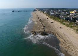
North Carolina Barrier Island Mitigation #1. Houses for Sale in Emerald Isle, NC
- Denis Raczkowski

- Apr 2, 2020
- 3 min read
Because of the hard (no pun intended) lessons learned in the older beachfront towns in New Jersey, Florida, and other states, the ocean-side beaches of North Carolina have fewer engineering mistakes on them. Beach community development in North Carolina occurred much later, and in closer proximity to our very recent understanding of coastal processes, especially those of how barrier islands survive and/or thrive.
Whether you choose to build or buy coastal property, you take risks. Those risks may come in the form of dramatic storms such as nor’easters or hurricanes that can destroy a home in a matter of hours. Or the risks may develop more gradually, caused by the daily forces of winds, waves and tides. These forces cause North Carolina’s beaches to shift. A beach may lose sand (erosion) or gain it (accretion). Erosion tends to occur faster in some areas than in others, especially near inlets and capes, where sand shifts rapidly. An eroding beach may lose several feet of sand a year. Yet, in spite of these and other risks, many people want to live along our ocean shore. So the N.C. Coastal Resources Commission (CRC) has established rules and development standards to evaluate the risk to life and property.

These rules, with rare exception, do not generally allow permanent or hard engineering along the North Carolina shoreline. As a result, replenishment, the pumping of sand onto the beach to build up the dunes and upper beaches has been the primary (but not the only) arrow in the mitigation quiver among the 29 beachfront communities in North Carolina.
Another arrow in the quiver includes erosion setbacks for oceanfront construction. These setbacks are based on average long-term erosion rates that reflect changes in our shoreline over nearly half a century. Evaluating these erosion rates is an exacting process that begins with aerial photographs of the ocean shoreline, photographs taken under specific conditions to ensure that the coast is in as normal a condition as possible. Then, the shoreline is marked, and its position (relative to a fixed shoreline baseline) is added to the existing database. Lastly, the position of the current shoreline is compared to the earliest available position; the distance between them is divided by the number of years between photographs to determine an average long-term erosion rate.
And if you’re planning to build along the oceanfront, the average erosion rate will determine where you can put your house. Current CRC rules require that for oceanfront buildings the minimum setback factor is 30 times the erosion rate for all structures less than 5,000 square feet, regardless of use. The setback factor for all structures between 5,000 and 10,000 square feet is 60 times the erosion rate and increases incrementally with structure size, reaching a maximum setback at 90 times the erosion rate for structures 100,000 square feet and greater. The erosion setback is a line, measured landward from the first line of stable, natural vegetation.
However, what is a “safe” setback is difficult to determine with absolute certainty. Erosion rates are not predictors. If the long-term average erosion rate at a certain location is 3 feet per year, it does not mean that beach will lose 3 feet of sand this year. It might lose less, or more. And, not all portions of North Carolina’s shoreline are eroding at the same rate. Generally speaking, the more or less east facing barrier islands to the north are eroding at a higher rate than the southern, south-facing islands. Indeed, these south-facing islands, protected from the ill effects of northeasters, report not only lower erosion rates than their northern brethren, but some also report accretion.
.png)


Comments